The map Esther posted is good...a basic hardiness zone map,
but if you want to pin point your zone (many people have 'micro-climates')
here is a chart from the AHS: American Horticultural Society that is extremely accurate:
All you need to know is what your
average lowest temps are in the winter.
Not the lowest ever recorded, or the lowest recorded that year, just your average low temps.
Like here in eastern LI, our average low temps get down to upper teens, low 20s.
Rarely does it get any colder than that, and if it does...maybe one night or two.
So Eastern LI is really a zone 8, contrary to what the map says,
cuz we have a microclimate due to all the water around us.

The map also busts the myth that if you tell someone what your hardiness zone is, you are 'narrowing it down too much'
on your location. As you can see from Esther's map...simply isn't true.
And if the map showed Canada, you'd see there are plenty of zone 7s and even 8s in Canada.
You wouldn't want to drive all through each zone 3 just to find Bart.


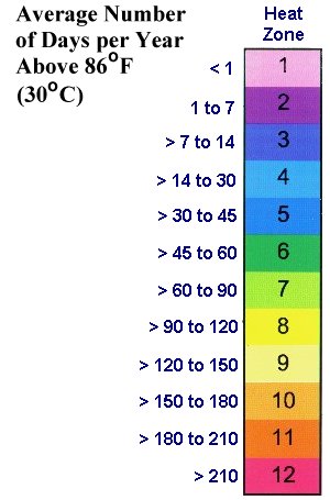
Now there is also a heat zone map, but I'll provide the chart once again, since it is more accurate than the map.
This map measures how heat tolerant your plants will need to be, or, the plants you
should be using in your garden.
Many nurseries and garden centers with any scruples are now using heat zone mapping too.